131212 | Environment Agency issue new Surface Water risk flood maps
Submitted by Angarrack.info ... on Thu, 12/12/2013 - 22:08.
Via http://watermaps.environment-agency.gov.uk/wiyby/wiyby.aspx?lang=_e&topi...
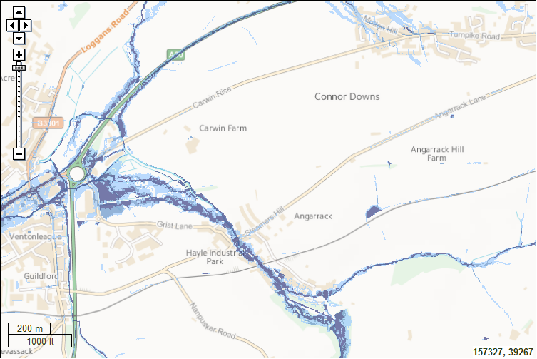
Risk of Flooding from Surface Water
Surface water flooding happens when rainwater does not drain away through the normal drainage systems or soak into the ground, but lies on or flows over the ground instead.
The shading on the map shows the risk of flooding from surface water in this particular area.
Click on the map for a more detailed explanation.
Map legend
Risk of Flooding from Surface Water

High

Medium

Low

Very Low
- Printer-friendly version
- Login or register to post comments
- Permalink
Contributions
- Angarrack Defibrillator Team (25)
- Angarrack Inn (336)
- Angarrack Methodist Chapel (3)
- Carol (15)
- Gail (1)
- GordonG (12)
- Hayle Development Group on Facebook (5)
- Hayle Harbour Authority (4)
- Hayle Town Council (5)
- louise (1)
- Lynne (94)
- Mal (1)
- Neil (22)
- Neils Garden Care (9)
- Russell (21)
- Secretary - Christmas Lights (118)
- Steve (3)
- webmaster (5023)
Book page
Similar
- 160908 | National Flood Resilience Review (NFRR) report published by Defra and the Cabinet Office
- 160907 | Met Office science behind the National Flood Resilience Review
- 141119 | Cornwall Storm Impacts update 19 November 2014 V1.3
- Flood alleviation ideas from other areas
- Angarrack Gauge Levels 2014 to date...
Similar across site
- 160908 | National Flood Resilience Review (NFRR) report published by Defra and the Cabinet Office
- 160907 | Met Office science behind the National Flood Resilience Review
- 141119 | Cornwall Storm Impacts update 19 November 2014 V1.3
- Flood alleviation ideas from other areas
- Angarrack Gauge Levels 2014 to date...


Recent comments
1 week 23 hours ago
36 weeks 5 days ago
38 weeks 3 days ago
38 weeks 3 days ago
48 weeks 1 day ago
1 year 8 weeks ago
1 year 33 weeks ago
1 year 43 weeks ago
2 years 3 weeks ago
3 years 27 weeks ago